Skip to content
Text from a manuscript reading Agmondesham als Amersham in the County of Bucks
  • Maps
  • Resources
  • Tools
Text from a manuscript reading Agmondesham als Amersham in the County of Bucks

map

Part of the Sheldon Tapestry Map showing Amersham
Research notes | Resources

Marvellous mapestry

Byoldamersham.uk 7 June 2025

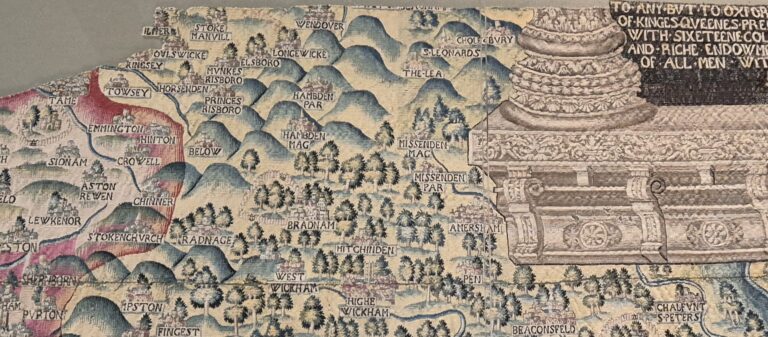
I went to the Weston Library in Oxford for a meeting. About maps, obviously. In the Blackwell Hall there is an enormous tapestry map, one of four, each of which covers one of four counties: Oxfordshire, Worcestershire, Gloucestershire and Warwickshire. The part…

Read More Marvellous mapestryContinue

Detail from the 1838 Tithe Map of Amersham
Research notes | Tools

QGIS and the trouble with tithes

Byoldamersham.uk 26 May 202526 May 2025

Georeferencing the 1838 tithe map to use as a guide for creating historical maps

Read More QGIS and the trouble with tithesContinue

Map created using Folium and Stamen terrain tiles
Research notes | Tools

Fun with Folium

Byoldamersham.uk 17 May 202525 May 2025

I’ve been looking at mapping tools and decided to have a play with Folium, a python library for mapping. The aim was to see how easy to use it was, and whether it had the flexibility to present geographical data in a…

Read More Fun with FoliumContinue

Map of Amersham in Felt
Research notes | Tools

Mapping tools

Byoldamersham.uk 7 December 202425 May 2025

I’ve been creating my maps so far in QGIS, which is excellent as well as being free and open source, but thought I’d give some other tools a try. I’ve been looking at Felt, an online mapping tool. It allows you to…

Read More Mapping toolsContinue

Detail from the John Speed Buckinghamshire map
Research notes | Resources

A county border anomaly

Byoldamersham.uk 7 May 202425 May 2025

The village of Coleshill, part of the parish of Amersham, Buckinghamshire was also once in Hertfordshire

Read More A county border anomalyContinue

© 2025 Old Amersham history

  • Maps
  • Resources
  • Tools